The opinion of Aventure Nordique
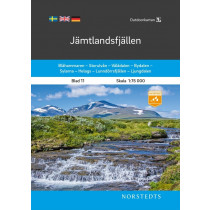
The Jämtlandsfjällen map from the Swedish publisher Calazo covers the mountains of Jämtland at 1:100,000, with Vålådalen, Lunndörren, Anaris and Oviksfjällen, as well as Åreskutan, Vemdalsskalet, Storulvån, Sylarna and Helags. The map shows the hiking trails and includes a legend in English.
Made of tyvek, a synthetic fiber, the map is waterproof and very tear-resistant. A tyvek map does not tear in folds and does not lose its color over time.
Technical details
| Manufacturer | Calazo |
|---|---|
| Country | Sweden |
| Type | Hiking map |
| Article number | 9789186773052 |
| ISBN | 9789186773052 |
| EAN | 9789186773052 |
| Date of publication | 2022 |
| Scale | 1:100 000 |
| Folded size | 13 x 21 cm |
| Weight | 55 g |
| Warranty | 2 years |
| Country of Manufacture | Sweden |
verified customer reviews 
Only customers who have ordered this product from us can give their opinion on our products, but you can contact us for questions, returns and advice.
Questions & Answers
Be the first to ask a question about this product
Related Products

You may also be interested


Remonter
Love the variety of p...
Love the variety of products to choose from that are made in Europe.
The product was deliv...
The product was delivered fast and was what I expected. Very good
Información sobre el ...
Información sobre el producto accesible, llegó en el plazo previsto, s...
Perfect experience an...
They know what they sell. Good advices, and professional sales process...
Everything went just ...
Everything went just perfect
Everything was fine
Everything was fine. I ordered a new tent. Good price.
Sempre magnífic
Sempre magnífic. Salut.
Great assortment and ...
Great assortment and good & fast service !
© 2010 - 2024 Aventure Nordique Ltd - Legal - Terms & conditions - Privacy policy - Manage your cookies