The opinion of Aventure Nordique
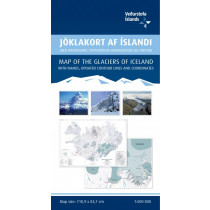
A quality hiking map (1: 100 000) that reaches from the outermost part of Reykjanes in the west to the east of Thingvallavatn. The map includes all hiking- and driving routes of the area, along with place names and other useful information. On the reverse side you will find a map of Thingvellir (1: 50 000) with descriptions and photographs of the area‘s main attractions. The map features drawings by Jón Baldur Hlíðberg
Technical details
| Manufacturer | Mal og Menning |
|---|---|
| Country | Iceland |
| Type | Hiking map |
| Series | Mal og Menning |
| Article number | 9789979330325 |
| EAN | 9789979330325 |
| Date of publication | 2017 |
| Scale | 1:100 000 & 1:50 000 |
| Folded size | 23,5 x 12,5 cm |
| Weight | 85 g |
| Additional information |
|
| Warranty | 2 years |
| Country of Manufacture | Iceland |
verified customer reviews 
Only customers who have ordered this product from us can give their opinion on our products, but you can contact us for questions, returns and advice.
Questions & Answers
Be the first to ask a question about this product
Related Products
You may also be interested
Remonter
Everything was fine
Everything was fine. I ordered a new tent. Good price.
Fast delivery and gre...
Fast delivery and great selection of products.
Buen servicio y rapid...
Buen servicio y rapidez
Great assortment and ...
Great assortment and good & fast service !
Rien à dire, top !
Rien à dire, top !
Fast delivery
Fast delivery. I´m very happy with my sleeping bag
Información sobre el ...
Información sobre el producto accesible, llegó en el plazo previsto, s...
Sempre magnífic
Sempre magnífic. Salut.
© 2010 - 2024 Aventure Nordique Ltd - Legal - Terms & conditions - Privacy policy - Manage your cookies