The opinion of Aventure Nordique
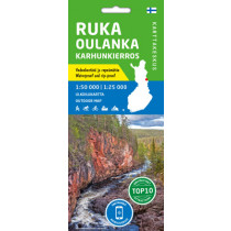
The outdoor map covers the town of Kuusamo and its vicinity. The scale of the map is 1:100,000 (1 cm on the map = 1 km on the ground).
The double-sided outdoor map covers a wide area on one sheet including the resort of Ruka, the centre of Kuusamo town, the national parks of Oulanka and Riisitunturi as well as the hiking areas of Hossa and Kylmäluoma. The most well-known hiking trail in the area is the Karhunkierros Trail. The map can be used for trekking and travelling. It shows hiking trails, snowmobile routes, kayak and canoe trails, white-water routes and cycling trails.
The map is based on a topographic map and has plenty of extra information for hikers and travellers, such as various trails and their lengths, wilderness huts, lean-to shelters, eating places, accommodations and sights.
On the side of the map you will find coordinates for all the wilderness huts to help locate them with a GPS device. Details on magnetic declination and the coordinate system have also been included.
Technical details
| Manufacturer | Karttakeskus |
|---|---|
| Country | Finland |
| Type | Hiking map |
| Article number | 9789522666765 |
| ISBN | 978-952-266-676-5 |
| EAN | 9789522666765 |
| Date of publication | 2021 |
| Scale | 1:100 000 |
| Folded size | 10 x 20,6 cm |
| Weight | 63 g |
| Warranty | 2 years |
| Country of Manufacture | Latvia |
verified customer reviews 
Only customers who have ordered this product from us can give their opinion on our products, but you can contact us for questions, returns and advice.
Questions & Answers
Be the first to ask a question about this product
Related Products
You may also be interested

Remonter
Love the variety of p...
Love the variety of products to choose from that are made in Europe.
The product was deliv...
The product was delivered fast and was what I expected. Very good
Información sobre el ...
Información sobre el producto accesible, llegó en el plazo previsto, s...
Perfect experience an...
They know what they sell. Good advices, and professional sales process...
Everything went just ...
Everything went just perfect
Everything was fine
Everything was fine. I ordered a new tent. Good price.
Sempre magnífic
Sempre magnífic. Salut.
Great assortment and ...
Great assortment and good & fast service !
© 2010 - 2024 Aventure Nordique Ltd - Legal - Terms & conditions - Privacy policy - Manage your cookies