


The opinion of Aventure Nordique
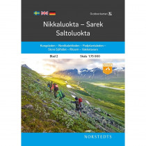
BD10 Sareks Nationalpark hiking and outdoor map. The map covers 3 national parks of Sweden: Sarek, Padjelanta and Stora Sjöfallets. This map allows you to discover the route to the west of Padjelantaleden: Akka, Kisuris, Låddejåkkå, Arasluokta, Staloluokta, Tuottar, Tarraluoppal, Såammarlappå (Tarradalen valley) Tarrekaise, Njunjes and Kvikkjokk. Some portions of the Nordkalottleden are represented: itinerary common with Padjelantaleden, then head south and linking Staddajåkkå and Pieskehaure. To the east, the map covers part of the Kungsleden, linking Vietas to Kvikkjokk (Saltoluokta, Sitojaure, Aktse and Rapadalen valley, Pårte). BD10 Sareks Nationalpark map is compatible with GPS (Sweref 99 TM grid).
Technical details
| Brand | Norstedts |
|---|---|
| Country | Sweden |
| Type | Hiking map |
| Series | Fjällkartan |
| Sheet reference | BD10 |
| Article number | 9789158895881 |
| EAN | 9789158895881 |
| Date of publication | February 2009 |
| Scale | 1:100 000 |
| Folded size | 14 x 20cm |
| Additional information |
|
| Warranty | 2 years |
| Country of Manufacture | Italy |

verified customer reviews 
Only customers who have ordered this product from us can give their opinion on our products, but you can contact us for questions, returns and advice.
Questions & Answers
Be the first to ask a question about this product
Related Products

You may also be interested


Remonter
Top
Für den Liefer Weg, echt schnell geliefert!
Wäre einwandfrei angekomme...
Everything worked out...
Everything worked out perfectly
very quick and effici...
very quick and efficient
A screw was missing f...
A screw was missing from my order. I emailed you as soon as it was del...
All perfect
All perfect
Excellent service
I ordered Alfa Free boots that are not available in Slovakia. Created ...
Good service and good...
Good service and good professional advice
Undecided on review
Undecided on review, order placed 10 days ago, have tracking number bu...
© 2010 - 2025 Aventure Nordique Ltd - Legal - Terms & conditions - Privacy policy - Manage your cookies