


The opinion of Aventure Nordique
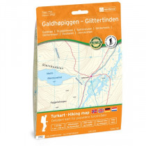
Hiking and outdoor Glittertinden. The Glittertind is the second highest mountain in Norway and Scandinavia (2465 meters). Glittertinden map gives a detailed description of the land, hiking trails and ski slopes. The map covers the top of Glittertind, the area of Glitterheim and lake Russvatnet. Map Glittertinden no. 2757 is compatible with GPS (UTM).
Technical details
| Brand | Nordeca |
|---|---|
| Country | Norway |
| Type | Hiking map |
| Series | Turkart |
| Sheet reference | 2757 |
| Article number | 2757 |
| ISBN | 7046660027578 |
| EAN | 7046660027578 |
| Date of publication | 2011 |
| Scale | 1:25 000 |
| Folded size | 12x23cm |
| Warranty | 2 years |
| Country of Manufacture | Norway |
verified customer reviews 
Only customers who have ordered this product from us can give their opinion on our products, but you can contact us for questions, returns and advice.
Questions & Answers
Be the first to ask a question about this product
Related Products
You may also be interested
Remonter
Staff were very helpf...
Staff were very helpful. My item wasn't available but they offered a b...
very quick and effici...
very quick and efficient
Very quick delivery.
Very quick delivery.
Product received in good order for a good price.
Werry satisfied with ...
Werry satisfied with all👍
Super efficient and g...
Super efficient and great service
Perfect shopping expe...
Perfect shopping experience.
Everything went great
Everything went great. Payment was easy, delivery was fast and the pro...
This if you ask me ri...
This if you ask me right now,
ordered some items, and the delivery da...
© 2010 - 2025 Aventure Nordique Ltd - Legal - Terms & conditions - Privacy policy - Manage your cookies