


The opinion of Aventure Nordique
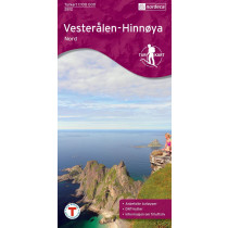
Map of South Vesterålen Archipelago. Covers Hinnøya South. Covers two long fjords: Gullesfjorden and Øksfjorden. It allows you to view the highest peaks: Møysalen, Tverrelvtindan and Stortinden. The cities covered: Straume, Sorland, Lødingen, Melbu, Straumnes. Compatible with GPS. Waterproof paper.
Points to remember
Compatible avec un GPS. Papier résistant à l'humidité.
Technical details
| Brand | Nordeca |
|---|---|
| Country | Norway |
| Type | Hiking map |
| Series | Turkart |
| Sheet reference | 2811 |
| Article number | 2811 |
| EAN | 7046660028117 |
| Date of publication | 2014 |
| Scale | 1:100 000 |
| Folded size | 14,3 x 20,8 cm |
| Weight | 54 g |
| Warranty | 2 years |
| Country of Manufacture | Norway |
verified customer reviews 
Only customers who have ordered this product from us can give their opinion on our products, but you can contact us for questions, returns and advice.
Questions & Answers
Be the first to ask a question about this product
Related Products

You may also be interested
Remonter
Top
Für den Liefer Weg, echt schnell geliefert!
Wäre einwandfrei angekomme...
Why send it in a box?
I do not understand why you would put two thin maps in a bigger box an...
A very good selection...
A very good selection of outdoor products. Fast shipment of products.
Excellent service
I ordered Alfa Free boots that are not available in Slovakia. Created ...
Perfect Service.
Perfect Service.
I appreciate the wide...
I appreciate the wide range of products, good contact and fast deliver...
Perfect shopping expe...
Perfect shopping experience.
Easier to order throu...
Easier to order through the website.
© 2010 - 2025 Aventure Nordique Ltd - Legal - Terms & conditions - Privacy policy - Manage your cookies