


The opinion of Aventure Nordique
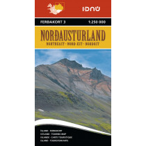
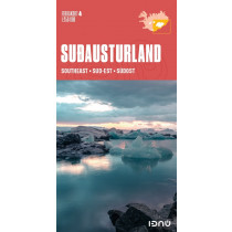
Touring Map 2 – Southwest Iceland. Quality section map showing the southwest of Iceland. The map has contour lines and shading at 50 m intervals, and contains the latest information about Iceland's road system, including road distances and road numbers, as well as important travel-service information such as service stations, accommodation, swimming pools, museums, protected relics, golf courses, viewing dials and boat trips.
Technical details
| Brand | Idnu |
|---|---|
| Country | Iceland |
| Type | Tourist map |
| Series | Idnu |
| Article number | FEK-00520 |
| EAN | 9789979675020 |
| Date of publication | 2021 |
| Scale | 1:250 000 |
| Folded size | 21 x 11 cm |
| Additional information | Languages: Icelandic, English, German and French |
| Warranty | 2 years |
| Country of Manufacture | Iceland |
verified customer reviews 
Only customers who have ordered this product from us can give their opinion on our products, but you can contact us for questions, returns and advice.
Questions & Answers
Be the first to ask a question about this product
Related Products
You may also be interested
Remonter
Great service
Great service, really helpful
Great online shop web...
Great online shop website and delivery on time
delay in delivery
delay in delivery
Profesional advice
Profesional advice
Item arrived in perfe...
Item arrived in perfect condition
The shipment still di...
The shipment still did not arrive, so what do you want to know?
Great selection at a ...
Great selection at a good price.
I appreciate the wide...
I appreciate the wide range of products, good contact and fast deliver...
© 2010 - 2025 Aventure Nordique Ltd - Legal - Terms & conditions - Privacy policy - Manage your cookies