


The opinion of Aventure Nordique
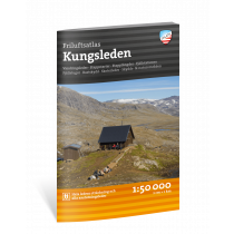
Map and trekking guide for Kungsleden in Sweden: Abisko - Kebnekaise: 106 km trek through Swedish Lapland (6/7 days).
Booklet including a 1:50000 scale map and a detailed guide to the Royal Route trek in Swedish Lapland. This map, number Kungsleden n°1, shows the hiking route from Abisko to Nikkaluokta. It covers the following stages:
- Abisko - Abiskojaure
- Abiskojaure - Alesjaure
- Alesjaure - Tjäktja
- Tjäktja - Sälka
- Sälka - Singi
- Singi - Kebnekaise
- Kebnekaise -Nilkkaluotka
The map is made from resistant paper. In the guide, the stages are described so that you can hike in both directions, north and south. Each stage is detailed with the distance covered, the approximate time, the altitude difference and the names of the refuges.
The division of the stages is based on the positioning of the huts belonging to the Swedish STF association on this long-distance hiking trail.
The booklet provides a wealth of information about hiking in the Swedish mountains, the organisation of huts, weather conditions, safety, etc...
As well as describing the routes, the booklet provides detailed information on each STF hut: photo of the hut, number of beds, provisioning facilities, services, etc.
The booklet also indicates alternative stages that deviate from the main itinerary, with an indication of the distance covered and the duration of the hike.
All information and descriptions are in English and Swedish.
Technical details
| Brand | Norstedts |
|---|---|
| Country | Sweden |
| Map Type | Hiking maps |
| Series | Outdoorkartan |
| Sheet reference | Kungsleden 1 |
| Article number | 9789113100852 |
| EAN | 9789113100852 |
| Date of publication | 2019 |
| Scale | 1:50 000 |
| Folded size | Unfolded: 96 x 65 cm - Folded: 22 x 12 cm |
| Weight | 170 g |
| Additional information |
|
| Warranty | 2 years |
| Country of Manufacture | Latvia |
verified customer reviews 
Questions & Answers
Be the first to ask a question about this product
Related Products
You may also be interested

L'avis de nos aventuriers

Ici, vous achetez en toute sécurité
Cette boutique répond aux critères de qualité de Trusted Shops

Protection acheteur
Votre achat est assuré jusqu'à 2500€ quel que soit votre mode de paiement