


The opinion of Aventure Nordique
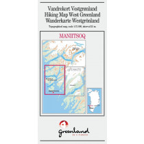
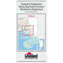
Hiking map of Tasermiut fjorden/Nanortalik, South Greenland. Scale of 1: 100 000. The map contains contour lines (interval 25m). Trails of trekking are indicated. Nanortalik plan, touristic informations in English and day hikes and kayaking.
Technical details
| Brand | Compukort |
|---|---|
| Country | Greenland |
| Type | Hiking map |
| Sheet reference | 5 |
| Article number | 5 |
| Date of publication | 1995 / 1996 |
| Scale | 1:100 000 |
| Folded size | 10x21cm |
| Warranty | 2 years |
| Country of Manufacture | Denmark |
verified customer reviews 
Only customers who have ordered this product from us can give their opinion on our products, but you can contact us for questions, returns and advice.
Questions & Answers
Be the first to ask a question about this product
Related Products
You may also be interested
Remonter
Top
Für den Liefer Weg, echt schnell geliefert!
Wäre einwandfrei angekomme...
Everything worked out...
Everything worked out perfectly
very quick and effici...
very quick and efficient
A screw was missing f...
A screw was missing from my order. I emailed you as soon as it was del...
All perfect
All perfect
Excellent service
I ordered Alfa Free boots that are not available in Slovakia. Created ...
Good service and good...
Good service and good professional advice
Undecided on review
Undecided on review, order placed 10 days ago, have tracking number bu...
© 2010 - 2025 Aventure Nordique Ltd - Legal - Terms & conditions - Privacy policy - Manage your cookies