


The opinion of Aventure Nordique
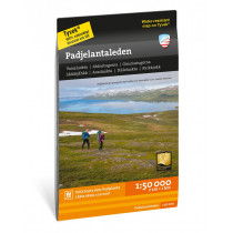
The Sareks nationalpark map from the Swedish publisher Calazo is a 1:50,000 map that covers the Sarek national park area. On the front side the highest peaks including the Sarektjåhkkå. On the reverse side the Rapadalen, the Bårdde massif and a part of the long distance hiking trail, the Padjelantaleden.
Made with the latest airborne laser scanning technique, the map is very accurate and perfectly reflects the reality of the terrain: rivers, rocks, vegetation boundaries, cliffs... This map indicates the hiking trails and includes a legend in English.
Made of tyvek, a synthetic fiber, the map is waterproof and highly resistant to tearing. A tyvek map does not tear in the folds and does not lose its color with time.
Technical details
| Brand | Calazo |
|---|---|
| Country | Sweden |
| Map Type | Hiking maps |
| Article number | 9789188335326 |
| EAN | 9789188335326 |
| Date of publication | 2020 |
| Scale | 1:50 000 |
| Folded size | 13 x 21 cm |
| Weight | 55 g |
| Warranty | 2 years |
| Country of Manufacture | Latvia |
verified customer reviews 
Questions & Answers
Be the first to ask a question about this product
Related Products
You may also be interested

L'avis de nos aventuriers

Ici, vous achetez en toute sécurité
Cette boutique répond aux critères de qualité de Trusted Shops

Protection acheteur
Votre achat est assuré jusqu'à 2500€ quel que soit votre mode de paiement