


The opinion of Aventure Nordique
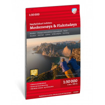
Høyfjellskart Lofoten: Moskenesøya & Flakstadøya is a Calazo map covering the southern part of Norway's Lofoten Islands. Thanks to its 1:30,000 scale, this map is accurate and suitable for all outdoor activities.
The terrain information shown on the map is based on aerial laser scanning data. Ridges, peaks, watercourses, glaciers and other natural features are represented in great detail using this technology. The map also includes all trails.
Høyfjellskart Lofoten: Moskenesøya & Flakstadøya covers the following locations: Mosken, Værøya Lofotoddens nasjonalpark, Reine, Munke, Ballstad, Leknes, Selfjordhytta, Ramberg.
This map is made from Tyvek, a water-resistant, tear-proof and lightweight material.
Technical details
| Brand | Calazo |
|---|---|
| Country | Norway |
| Map Type | Hiking maps |
| Article number | 9789188779847 |
| EAN | 9789188779847 |
| Date of publication | 2024 |
| Scale | 1:30 000 |
| Folded size | 13 x 21 cm |
| Weight | 55 g |
| Warranty | 2 years |
| Country of Manufacture | Latvia |
verified customer reviews 
Questions & Answers
Be the first to ask a question about this product
Related Products
You may also be interested

L'avis de nos aventuriers

Ici, vous achetez en toute sécurité
Cette boutique répond aux critères de qualité de Trusted Shops

Protection acheteur
Votre achat est assuré jusqu'à 2500€ quel que soit votre mode de paiement