


The opinion of Aventure Nordique
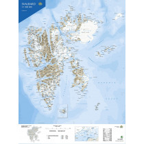
Topographic map of the Svalbard Archipelago. North-Western part at a scale of 1:250,000. Map edited by the Norwegian Polar Institute (Norsk Polar Institutt). Contains a detailed index of geographical features, a glossary and rules for visitors.
The map shows roads, tracks or paths, as well as airfields and heliports, lighthouses, etc...
The map covers the northwestern part of Spitsbergen, the Norwegian island belonging to the Svalbard archipelago. With an area of 39,044 km², it is the only inhabited island of the archipelago. The largest city is Longyearbyen with about 1600 inhabitants located on the edge of the Adventfjorden fjord. You can see the area of Ny-Ålesund, the northernmost town in the world! Map with legend in Norwegian and English.
Technical details
| Brand | Norwegian Polar Institute |
|---|---|
| Country | Spitzbergen |
| Map Type | Hiking maps |
| Sheet reference | Svalbard nordvest (S250)-Blad 2 |
| Article number | 711502 |
| Date of publication | 2025 |
| Scale | 1:250 000 |
| Folded size | 13 x 24 cm |
| Weight | 85 g |
| Warranty | 2 years |
| Country of Manufacture | Norway |
verified customer reviews 
Questions & Answers
Be the first to ask a question about this product
Related Products
You may also be interested

L'avis de nos aventuriers

Ici, vous achetez en toute sécurité
Cette boutique répond aux critères de qualité de Trusted Shops

Protection acheteur
Votre achat est assuré jusqu'à 2500€ quel que soit votre mode de paiement