


The opinion of Aventure Nordique
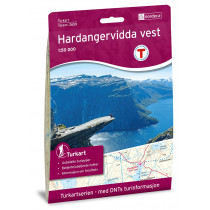
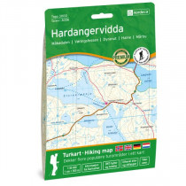
Topographic map at 1:100 000 Hardangervidda Øst edited by Turkart - Tour maps with information that ski runs, fotruter, resorts and tourist cabins. The map also has a text page with current information. These place names located within the map: Austbygdi , Bjornesfjorden , Borgsjåbrotet , Dagalifjell , Fliseggi , Gaustatoppen , Geilo , Hallingdal , Hallingskarvet , Halnefjorden , Hardangervidda , Kalhovd fjord , Kvennedalen , Langesjøen , Miland , Måna , Marten , Møsvatn , Numedalslågen , Rjukan , Rødungen , Tessungdalen , Tunhovdfjorden, Ustevatn , Uvdal.
Technical details
| Brand | Nordeca |
|---|---|
| Country | Norway |
| Type | Hiking map |
| Series | Turkart |
| Sheet reference | 2556 |
| Article number | 2556 |
| EAN | 7046660025567 |
| Date of publication | 2018 |
| Scale | 1:100 000 |
| Folded size | 14,2 x 20,6 cm |
| Weight | 55 g |
| Warranty | 2 years |
| Country of Manufacture | Norway |
1 verified customer reviews 
Posted on 12/11/2024
Questions & Answers
Be the first to ask a question about this product
Related Products
You may also be interested
Remonter
Top
Für den Liefer Weg, echt schnell geliefert!
Wäre einwandfrei angekomme...
Why send it in a box?
I do not understand why you would put two thin maps in a bigger box an...
A very good selection...
A very good selection of outdoor products. Fast shipment of products.
Excellent service
I ordered Alfa Free boots that are not available in Slovakia. Created ...
Perfect Service.
Perfect Service.
I appreciate the wide...
I appreciate the wide range of products, good contact and fast deliver...
Perfect shopping expe...
Perfect shopping experience.
Easier to order throu...
Easier to order through the website.
© 2010 - 2025 Aventure Nordique Ltd - Legal - Terms & conditions - Privacy policy - Manage your cookies