


The opinion of Aventure Nordique
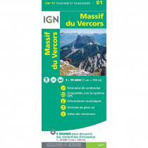
IGN's Top 25 3136 ET is a 1:25000 hiking map. It covers the south-western part of the Vercors massif and part of Royans. Thanks to it, you can discover Vassieux en Vercors, the Col du Rousset, the Grands Goulets, the Ambel plateau, the Roc de Toulau, Font d'Urle, the Léoncel abbey, the Royans walnut groves...
Technical details
| Brand | IGN |
|---|---|
| Country | France |
| Map Type | Hiking maps |
| Series | Top 25 |
| Article number | 46024 |
| EAN | 9782758552192 |
| Date of publication | 2022 |
| Scale | 1:25 000 |
| Folded size | 9,6 x 14,3 cm |
| Weight | 100 g |
| Warranty | 2 years |
| Country of Manufacture | France |
verified customer reviews 
Only customers who have ordered this product from us can give their opinion on our products, but you can contact us for questions, returns and advice.
Questions & Answers
Be the first to ask a question about this product
Related Products
You may also be interested

Remonter

 Find out more
 Find out more
L'avis de nos aventuriers
Tip-top experience
Very satisified with the whole process, the handling and shipping was ...
Fast shipping
Fast shipping, perfect experience!
I found niche items t...
I found niche items that were hard to get hold of elsewhere and the sh...
Fast delivery
Fast delivery. Great products
One of the best (web)...
Everything was great, website, service, answering questions. Very frie...
Unnecessarily complic...
Unnecessarily complicated retour procedere for defective items.
Checkout experience a...
Checkout experience and international shipping experience are excellen...
Price and quality are...
Price and quality are good. Web site usability is nice. Destination s...
Ici, vous achetez en toute sécurité
Cette boutique répond aux critères de qualité de Trusted Shops
Protection acheteur
Votre achat est assuré jusqu'à 2500€ quel que soit votre mode de paiement
© 2010 - 2026 Aventure Nordique Ltd - Legal - Terms & conditions - Privacy policy - Personal data - Manage your cookies