


The opinion of Aventure Nordique
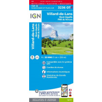
IGN's Top 25 3236 OT is a 1:25,000 hiking map. It covers part of the Traversée du Vercors (GR91), but also the GRP Tour du Vercors Dromois and many other marked trails. The map covers the following areas: Grand Veymont, Grande Moucherolle, Mont Aiguille, Col de l'Arzelier, Réserve Naturelle des Hauts-Plateaux, Col du Rousset... The following communes are covered by the map: Villard de Lans, La Chapelle en Vercors, St Julien, St Agnan, Corrençon, Le Gua...
Technical details
| Brand | IGN |
|---|---|
| Country | France |
| Map Type | Hiking maps |
| Series | Top 25 |
| Article number | 46073 |
| EAN | 9782758552819 |
| Date of publication | 2022 |
| Scale | 1:25 000 |
| Folded size | 9,6 x 14,3 cm |
| Weight | 100 g |
| Warranty | 2 years |
| Country of Manufacture | France |
verified customer reviews 
Only customers who have ordered this product from us can give their opinion on our products, but you can contact us for questions, returns and advice.
Questions & Answers
Be the first to ask a question about this product
Related Products
You may also be interested
Remonter

 Find out more
 Find out more
L'avis de nos aventuriers
Nortent Vern 1
I bought a tent made in Norway from this store in France, and the tent...
Happy with the goods ...
Happy with the goods and with delivery. No troubles at all. Thank you ...
Tip-top experience
Very satisified with the whole process, the handling and shipping was ...
Fast shipping
Fast shipping, perfect experience!
I found niche items t...
I found niche items that were hard to get hold of elsewhere and the sh...
Fast delivery
Fast delivery. Great products
One of the best (web)...
Everything was great, website, service, answering questions. Very frie...
Unnecessarily complic...
Unnecessarily complicated retour procedere for defective items.
Ici, vous achetez en toute sécurité
Cette boutique répond aux critères de qualité de Trusted Shops
Protection acheteur
Votre achat est assuré jusqu'à 2500€ quel que soit votre mode de paiement
© 2010 - 2026 Aventure Nordique Ltd - Legal - Terms & conditions - Privacy policy - Personal data - Manage your cookies