


The opinion of Aventure Nordique
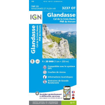
IGN's Top 25 3237 OTR is a 1:25,000 scale, heavy-duty, double-sided hiking map. It covers the southern part of the Hauts-Plateaux du Vercors Nature Reserve. If you want to hike the ridges starting from Col du Rousset, photograph the hooked pine on the Queyries plain, explore the wide-open spaces of Glandasse, watch bearded vultures above Archiane, hike the Jocou ridgelines, ski up to the Hauts-Plateaux via the Vallon de Combeau, you'll find all the trails, springs and sheepfolds on this map.
Technical details
| Brand | IGN |
|---|---|
| Country | France |
| Map Type | Hiking maps |
| Series | Top 25 |
| Article number | 46072 |
| EAN | 9782758552840 |
| Date of publication | 2022 |
| Scale | 1:25 000 |
| Folded size | 9,6 x 14,3 cm |
| Weight | 100 g |
| Warranty | 2 years |
| Country of Manufacture | France |
verified customer reviews 
Only customers who have ordered this product from us can give their opinion on our products, but you can contact us for questions, returns and advice.
Questions & Answers
Be the first to ask a question about this product
Related Products
You may also be interested
Remonter

 Find out more
 Find out more
L'avis de nos aventuriers
Tip-top experience
Very satisified with the whole process, the handling and shipping was ...
Fast shipping
Fast shipping, perfect experience!
I found niche items t...
I found niche items that were hard to get hold of elsewhere and the sh...
Fast delivery
Fast delivery. Great products
One of the best (web)...
Everything was great, website, service, answering questions. Very frie...
Unnecessarily complic...
Unnecessarily complicated retour procedere for defective items.
Checkout experience a...
Checkout experience and international shipping experience are excellen...
Price and quality are...
Price and quality are good. Web site usability is nice. Destination s...
Ici, vous achetez en toute sécurité
Cette boutique répond aux critères de qualité de Trusted Shops
Protection acheteur
Votre achat est assuré jusqu'à 2500€ quel que soit votre mode de paiement
© 2010 - 2026 Aventure Nordique Ltd - Legal - Terms & conditions - Privacy policy - Personal data - Manage your cookies